
Ladies and gentlemen, the Klown Show has been put on hiatus for retooling.
My ankles are still in a bad state, so we’re plotting and scheming about a few days of R&R to buy me some time to recover. Stay tuned for updates.
Daily dispatches from the Long Trail.
Ladies and gentlemen, the Klown Show has been put on hiatus for retooling.
My ankles are still in a bad state, so we’re plotting and scheming about a few days of R&R to buy me some time to recover. Stay tuned for updates.
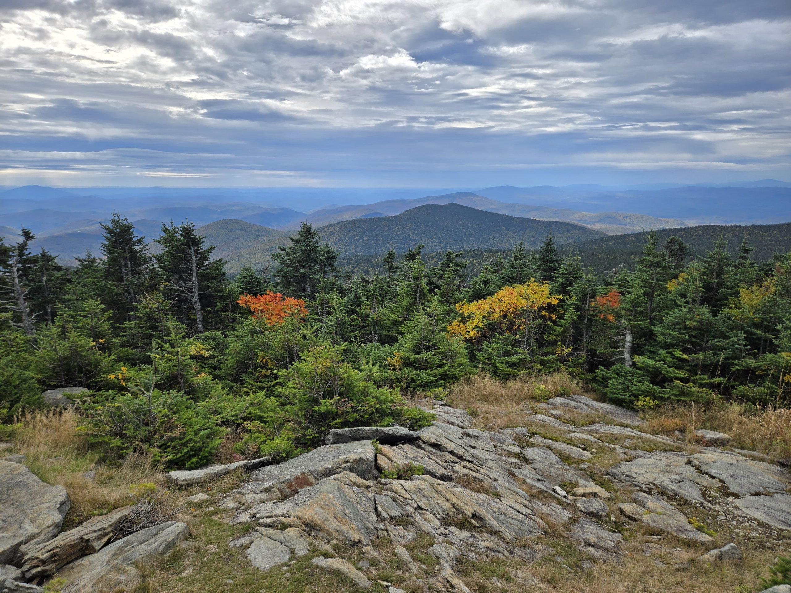
Because Spencer, my shelter companion, works at Target and gets up super early, I got up at 5:15AM this morning and was on trail before sunrise. It was a long sidehill climb up Mt Killington before dropping my pack and doing the brief but brutal summit scramble. The view was spectacular and well worth the price of admission.

I filtered some delicious water from the spring next to Cooper Lodge, the highest shelter on the Long Trail, and one which has seen better days. I then dragged myself down the ridge to Jungle Junction, where I opted to take the Sherburne Pass blue blaze over the newer LT/AT route. The blue blaze is actually the original AT, but it crosses private property in the form of Pico Ski Area, and the AT has a policy against private property. It also has the advantage of emerging directly across the street from the Inn at Long Trail, a famous hiker friendly inn and also my long anticipated stay for the night.

On the way down, my ankles started to really bother me, and I spent some time lying on my back with my socks and shoes off, feet in the air and head downhill, much to the consternation of several dayhikers who passed by. Thru hikers are an odd breed, I’ve discovered, and I find joy in this kinship.

I eventually struggled my way down to my destination and checked in. It’s a gorgeous old Vermont lodge, with an Irish Pub and a big lounge area offering multiple musical instruments, of which I availed myself. I also availed myself of the Pub. The Guinness Stew was amazing.

Liz arrived with her friends Jen and Scott, and we had a lovely time over another meal and drinks in the Pub. But I’m still on hiker time and fading fast, so I’ll save stories of “Fire Walker” and the dancing woman with the dog named “BB” for another post.

I’m taking a zero tomorrow to let my ankles recover, hopefully, and to sit out at least part of the Nor’easter pushing into the area.
I woke up with a lot more energy today, and the trail was in great shape most of the day. There were a few actual views, and the descent into Clarendon Gorge, across the swaying suspension bridge and back up the super step gully was spicy. I broke the tip off one of my poles going up that gully — an unfortunate incident with a boulder.

Early on, another NOBO LT thru hiker named Spencer caught me as I was dallying, taking a photo of a flower. He’s a nice young lad with a giant beard, which I later learned he’d been growing since puberty, which reminded me of Oskar. He said he’d be staying at this particular shelter that I’d been flirting with trying to reach, and that lit a bit of a fire under me. I encountered him again at another random shelter, and we sought some blazes together. We discussed a side trek to a farmstand a little ways off trail a few miles ahead, which he was hoping to visit for lunch. More like afternoon snack for me.

As the day dragged on, I slowed down, and the notion of stopping at the farmstand came into conflict with the idea of making it to my target shelter. I could’ve camped nearby, and it would have been glorious, but that would’ve left more miles than I wanted to hike tomorrow — did I mention I’m meeting Liz tomorrow afternoon? — so I decided to press on, knowing it would be a slog.

This last section really was a test of mental over physical. I was slow as molasses, but I made it to the shelter because I Just. Kept. Moving. My body is exhausted, and my ankles are gross, but I’m feeling pretty proud of myself. 14.1 miles and over 3k feet of both elevation gain and elevation loss is a lot for me.

I met Spencer at the shelter, and he looked both surprised and glad to see me. Spencer is an aspiring history PhD or possibly an aspiring lawyer from outside Worcester who’s also doing the LT as his first thru hike. He’s a vegan, and he has a wicked fear of heights. He’s a human abacus when it comes to calculating mileage. And he had the same MC Escher interaction with the tie dye guy, who I learned is named “Char”.

Then a SOBO AT section hiker named “Banker” joined us. Banker is a chatty older guy (only 6 years my senior), who good-naturedly talked our ears off most of the evening. He grew up in New York but moved to Atlanta to raise his family. He’s now retired, volunteers for the trail crew in Georgia, and is piecing together the AT. We bonded over some places we used to hike in CT as kids.

It was nice having some connection and conversation after 4 nights bedding down solo.

Tomorrow, the rains arrive at some point. And so does Liz. 10 miles and change to the Inn at Long Trail.

Today was a struggle. I started with no energy and had to call it early after “only” 10 miles on mostly rolling, not excessively rocky or rooty, without any major peaks, trail. I slowed to an absolute crawl on a 100′ PUD (pointless up and down) and decided to plop down for an early lunch and to try to figure out what the what.

My ankles had been bothering me. My ankles have never been a problem when I wasn’ t breaking them playing hockey. I rolled my socks down and was astonished to discover I’d sprouted cankles. I couldn’t even see my ankle bones for the swelling. The Internet later informed me that I have edema, a swelling of the ankles not uncommon amongst new thru hikers. While it was nice to have something to distract me from my creaky knees, horribly swollen ankles are no good for cranking out the miles either.
I was faced with a conundrum: Stop at a nice brookside with a great campsite upstream of a picturesque waterfall or push on a few more miles and up another 1000 feet, with questionable campsites and water sources to get a little closer to my destination on Saturday. I’d originally hoped to make it to the next shelter, 5 miles distant, but that was now out of the question. The brookside campsite with a couple hours to chill was my choice.

I soaked my feet in the icy cold stream. I stuck them up in the air while laying on my back. I took some Ibuprofen. Not sure which of these had the most impact, but I’m feeling a lot better now, albeit lying comfortably in my sleeping bag. I ate a whole bunch of food, too, so here’s hoping I get my energy back tomorrow.

I did see a very nice pond today, Lost Pond, with trees on the far back just starting to turn. On the way there, I ran into two SOBO thru hikers, neither of whom shared their name.
The first had a German accent, and said he’d been on trail since August, but had had to take a few zeros (days with no hiking) to restore his own creaky knees. He seemed somewhat disgusted with the state of the trail in the North, which is a lot rougher than what I’m tackling here.

The second was a dude with a big beard and a tie dye, whose first words to me were “do you know M.C. Escher?”, to which I responded in the affirmative after asking him to repeat himself only once. He then asked if I was familiar with the piece “Three Worlds”. I asked him to describe it, then said that yes, I did recall it. He said, “Lost Pond is like that.” He seemed utterly bemused with his observation. It turns out he’s doing the AT. I’ve encountered a couple folks doing the AT SOBO. I wonder how far they’ll get before the weather knocks them off trail — maybe all the way in an El Niño year?
I also exchanged pleasantries with a couple gents who must’ve been extras in Good Will Hunting. They’re section hiking the LT, Killington to Bromley over six days this time — I can’t help but think that’s the sort of pace I should’ve set for myself. They reported that there is indeed a bubble of NOBO LT hikers a couple days ahead of me, and that every shelter had been shared with several folks. I’m on five consecutive days of camping by myself, though three of those were tenting. Assuming I make it to The Inn at Long Trail in one piece, that’ll change the day after tomorrow.

The sunrises on Bromley Mountain are almost as nice as the sunsets. I enjoyed this one, then set off down a long descent off the northern flank on a clear, cold, blister morning. The terrain was bouldery and muddy, the theme for much of the day, but I made good time on this first section, as it eventually leveled out.
I emerged on a forest road, took a moment to snack and enjoy the sunshine, then started the climb up Styles Peak, which was under 2k feet but felt more like 3 — steep, rocky and unrelenting. Styles did offer a small view, unlike its neighbor Peru Peak along the uneven ridge to the north.

I was navigating a precipitous little drop between the two outcrops when I encountered “McGoober”, a woman hiking SOBO and attempting to best her previous LT completion time of 15 days by one day to finish in 14. That’s 272 miles in 14 days, or almost 20 miles a day on average, if you’re keeping track at home. That’s not unusual for thru hikers on some other popular trails, but it blows my mind on a trail like this. She was full of encouragement, hinted at a trail name for me, mentioned a bubble of NOBO hikers about 2 days ahead, and then was off like a shot up the steep rocks I’d just picked my way down. Curse these old knees.
My knees also had a laugh at the climb straight up a band of bedrock to the top of Mt Baker. A bit gratuitous, but I could imagine the twinkle in the eye of the trail designer. And there was a small view. I also encountered my first bag weather bypass, which thankfully I did not require.

From there, a long stretch of green tunnel, mostly downhill, led me through the Peru Peak Wilderness and then the Big Branch Wilderness. So much green. Lots of rocks and roots and mud, lots of boards in various states of disrepair through bogs, and a few sublime flat rolly sections. It all kinda blended together. There was one really nice pond, with a few trees on the far shore turned brilliant colors. But mostly a lot of slog.
I came across the Lost Pond Shelter, which I’d been considering as a bailout option, as my energy waned. It was a bright, recently rebuilt shelter near a babbling brook, and I was sorely tempted to set up there. But I really wanted to get a couple more miles, to make Fri and Sat a little shorter, given some weather predicted to move in.

This is something I spend way too much time thinking about: How to link together shelters and tent sites to get the right number of miles each day to get to my rendezvous with my partner Liz, who’s joining me at the Inn at Long Trail near Killington on Sat to hike the rest of the trail with me. It’s a lot of miles, and it feels more forced march than woods wander at the moment. I’d had this idea that I’d take the first 100 miles to warm up with lower mileages, but somehow I’ve ended up hiking a lot further each day than I’d intended. Maybe losing that first afternoon to iffy weather cost me, not sure. But I’ll keep putting one foot in front of the other and see where that gets me.
I’m currently camped by the Big Branch, which is a proper stream, with a suspension bridge and everything. It’s a serene spot and a good night for tenting. The shelter nearby is not rated very highly. I grabbed water and hung out by the stream for a while, watching the waning sun dip behind the tall trees lining the gorge downstream.

When I motivated to start working on dinner, my lighter didn’t work, not even generating a spark. For whatever reason, I forgot to bring a backup ignition source. I used to always carry a ferrule in my infamous pink possibles bag, for years and years, but I left that at home this time to save weight. So I started figuring out what I could eat to get some calories in me (chicken packets and peanut butter) while problem solving how I’d be able to get another lighter or some matches out here (beg other hikers, few and far between or try to hitch from a trailhead 1.5 miles away). Meanwhile, I’d stuck my lighter in my pocket to warm it and possibly dry it, and sure enough, when I tried it one more time after pretty much giving up on a hot meal, it lit right up. Whew. Just wet from the pot where I’d been keeping it, never a problem for me in the dry West.
So I cooked up some carbs and got them in me with little joy. Now I’m in my tent listening to the stream and still feeling a little on edge. I’m absolutely smoked, and it would be advantageous if I could put in 14.4 miles and a little under 3k feet of vertical tomorrow. I don’t know if my body is up to that again, but I suppose we’ll see.

Really nice weather today.
Resupply day! I woke up this morning, filtered some water, made some breakfast and coffee, packed my bag, put on some tunes, and got down to business. The miles flew by as the AT/LT uncharacteristically stuck to an old road or railroad bed for a while. The weather was cool and breezy, but sunny, and I was motivated to get my butt to town for my first resupply of the trip.

I paused at Prospect Rock, with its view overlooking Manchester Center, the town in question, and then, true to form, the trail took a 90 degree turn off of the road and got back to the rocks and roots it prefers. I passed Spruce Peak, with its famous no views, then Spruce Peak cabin, where I availed myself of its privy.

Then a German shorthair bounded up the trail and made my acquaintance, followed by its owner, a day hiker who’d previously hiked a 100 mile stretch of the LT and dreamed of doing the whole thing — a common theme among day hikers in these parts, it seems. The day hiker surprised me daydreaming on his way back, and asked if I needed a ride to town, then said he’d wait for me in the parking lot, thus solving my hitchhiking situation in a record negative 30 minutes.

I met Tom, the day hiker, down at the busy highway leading East from town and piled into his truck with his dog, Kopy. Tom is working odd jobs after leaving his 26 year stint working the ski and mountain biking shops at Stratton. He asked where I wanted to go, and I said I needed a burger, some groceries and a fuel canister, not necessarily in that order. He said, ‘nope, you don’t need a fuel canister!’, and magically produced one from underneath the passenger seat, which he happily gave to me. I’d heard of trail magic, but I’d never imagined it manifesting like this. It turns out Tom had had access to a large stock of these fuel canisters which had been decreasing in value until they became free. Thanks, Tom!

He dropped my at the Price Chopper, where I dropped my pack at the service desk and made slow work of assembling my next pile of food and repackaging it into ziplock bags. Then I wandered across the street and ordered a burger with both fries and a side salad and absolutely devoured them. I was tempted by a lunch beer — Lawson’s on tap — but held off because I knew I had a few more miles to put in. Uncommon restraint, I know. I chatted up the woman sitting at the table next to my outside, and ended up donating the rest of my box of ziplocks to her church. She’d watched my pack while I went inside to order, so it seemed only fair.

After I finished up and went to the WC, where I washed my hands — with soap! — I texted Tom, but he’d already taken off back over the hill to where he lives. So I walked a block and experimentally extended my thumb for the first time in my life. And like some perfect fly fishing cast, the second car that passed me put on their blinker and pulled over. There’s no way hitching is meant to be this easy. Especially for a somewhat haggard and not so fresh smelling 6’4″ dude.

Anne, a kind woman some number of years my senior, had classical music playing, so I knew she was good people. She used to pick up hitchhikers all the time, only recently resuming the practice. She asked if I needed to make any more stops in town. Very considerate. Her husband recently had his ankle replaced, but was hoping to get back to skiing this season. He used to work ski patrol for Bromley. Anne regaled me with stories of unfortunate and bedraggled thru-hikers of yore, and we arrived back at the trail altogether too soon, in my opinion. I asked if she or her husband were beer drinkers, and she replied enthusiastically that they were, so I gave her two Focal Bangers from the 4-pack I’d bought and wished her well.

The other two went into my pack as I began the climb up Bromley Mountain to the ski patrol shack there, which is open to hikers during hiking season. It has no water available, so I filtered on the way up, ensuring, with my resupply and beers, that my pack was at its maximum heaviest for the climb. Fortunately, it was only a few miles, and I found myself on top without too much of a struggle.
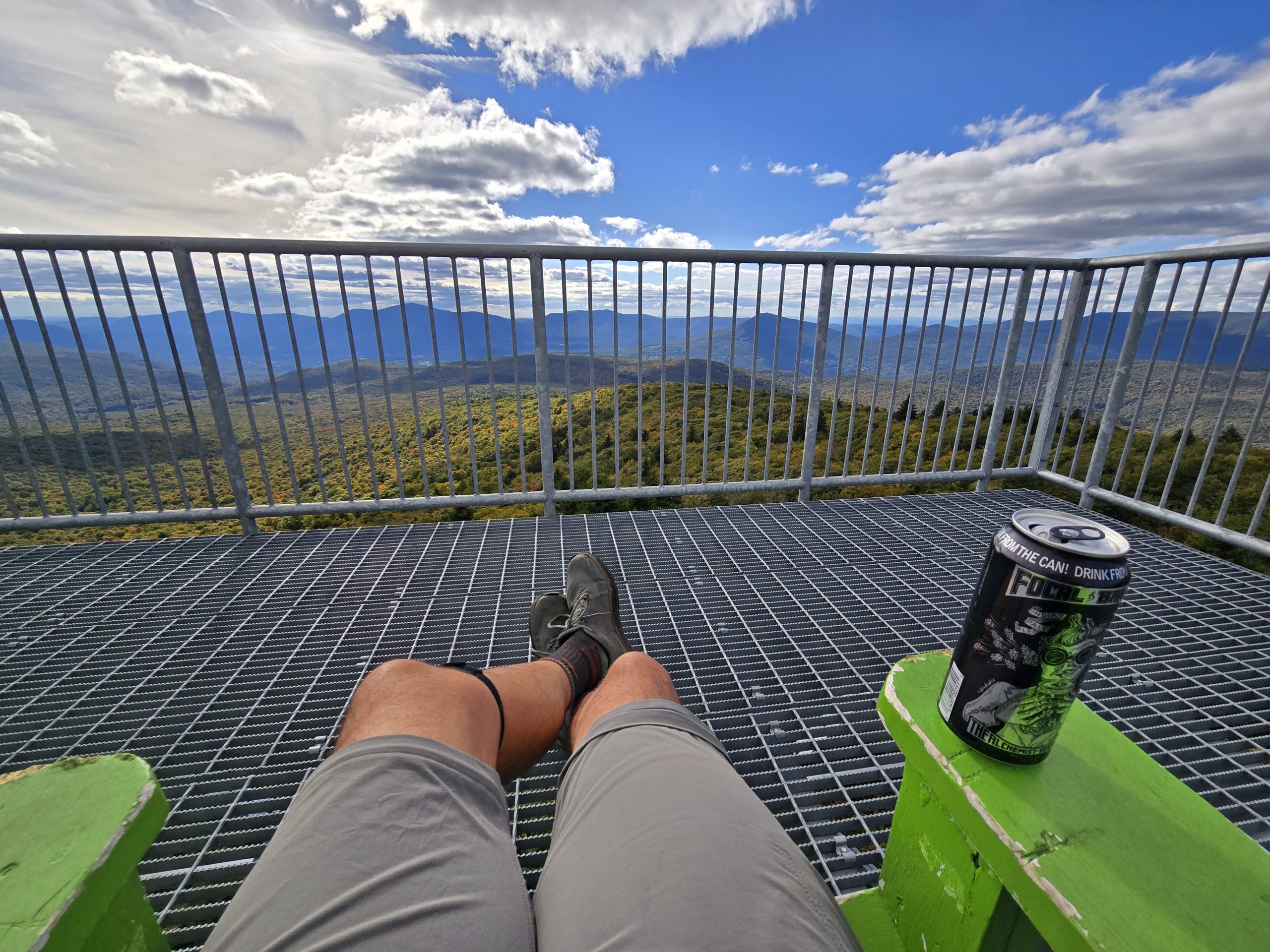
The top of Bromley is utterly delightful. There is a sturdy viewing tower with two Adirondack chairs placed on top. There is the aforementioned ski patrol shack, with power outlets, cell service and, get this, an operational dryer. There is a privy in the woods across a ski run. And the weather is spectacular — cold and windy, but mostly clear. As I sat atop the tower with one of my favorite beers and took in the 360 degree view of the Vermont mountains, with trees just starting to turn, I couldn’t help but think about how much my outlook has improved since my soggy camp along Black Brook and the tedious slog to my shelter last night. I’m grateful for good people, good weather, good views and good beer.

45 miles to my next resupply.
I woke to blue skies this morning, optimistic, if a bit reluctant to pack up my muddy tent. After procrastinating a while, I managed to hit the trail about 30 minutes later than usual, and set about the task of climbing Stratton Mountain.

I met a late AT SOBO hiker at a road crossing, “Lex”, and she was full of positive energy. I soaked up the sun for a minute, then ducked back into the green tunnel, where a mostly gradual climb over a mix of good trail and boulders posing as trail led me to “Somerset View”. It was a pretty sad excuse for a view, but given how infrequent views have been so far this trip, I appreciated that it was at least sunny, which would be pretty great for the fire tower views atop Stratton.
My hopes were dashed as I approached the final few hundred feet of vertical and was suddenly enveloped in blowing fog. I reached the top and climbed the first couple flights of the rickety tower, to no avail. Rats.

Well, at least I might get a hot meal for lunch, as hikers can ride the ski area lift down to the snack bar at the base and then back up again. I wandered the 0.75 miles over to lift central, and discovered that the lifts were out of commission for maintenance. Rats again.
Well, at least I had a few bars of 5G up on top, which did allow me to check in and post a couple blog posts. That actually worked out, but as I wandered back to the tower, the sun flashed out for about five minutes. I ran into a group at the bottom of the tower who said they’d been at the top when that happened, and they had the best views for about five minutes. Rats, rats, rats.
So down the trail I continued, downhill through mud, roots and rocks for miles, until I eventually came to Stratton Pond. The famous view involves a short diversion on a blue blaze, but it was worth it, even if the weather had continued cold and grey.

And then it was seemingly endless miles through the Lye Brook Wilderness, pretty enough, and mostly flat. The trail at this point felt a bit monotonous and aimless, though I’m sure it was mostly down to me being pretty darned tired. I don’t think I’ve been getting anywhere near enough calories, something I’ll have to fix with my resupply tomorrow.
I eventually arrived at William Douglas Shelter, which for probably some good reason is located half a mile off the LT/AT. It’s pretty dark, and there have been reports of many mice in this one. But it’s dry, and there’s a spring nearby, and I’m bone tired, so it’s home for now. No companions here — just me and the mice tonight.

With side excursions, albeit packless, I put in about 15.5 total miles today. Oof. Less tomorrow.
It rained today. All day. It’s still raining. The forecast called for a solid, soaking rain, and it did not disappoint.

The day started with a short climb in an intriguing fog to the top of Glastenbury Mountain, where the fire tower has been deemed unsafe and closed to hikers, but there would have been no view anyway. It wasn’t raining at this point, or maybe it was, but I only felt it when a gust of wind would let loose a cluster of droplets from the canopy overhead. “Perhaps this will be a shorts and shell with the hood down day”, I naively hoped.

When I arrived at Kid Gore shelter and sat down to a morning snack, the skies opened up into a steady, drenching rain. This was not a Colorado rain, cold and violent, but brief. It was a sprawling, persistent, soaking rain, not icy, but not exactly warm, either, not in this season.
I cooled off quickly, so I pulled on my rain pants, pulled up my hood, popped in an audiobook on my earbuds, and set off down the increasingly sodden path. A quick uphill warmed me up, but most of the day was rolling or downhill, a nice change of pace compared to yesterday’s climbs and descents.

As the miles of green tunnel rolled on, I felt simultaneously appreciative of the thing that makes these hills so verdant and annoyed at its unrelenting persistence. Just as I was thinking about how fortunate I’d been not to have any slips so far, I slipped once, then again, then took a bonafide tumble — nothing injured or even bruised, thankfully. The trail was pretty tricky today, with lots of roots and boulders and puddles and deep mud, and less easy cruising. It was slow going, for sure.

I arrived at Story Spring shelter, and was faced with a decision: Stop and set up camp in a small but dry shelter at 2PM or knock out another 3 miles of mostly downhill and make tomorrow’s climb up Stratton Mountain that much shorter. I chose the latter, even though it meant setting up a tent. The last forecast I saw suggested that the rain was about to taper off, and the tent site at Black Brook was supposed to be pretty nice.

And so it was that I found myself chilled, standing in a downpour, staring at the puddles that would’ve made fine tent sites in better weather, and feeling pretty sorry for myself. It’s a beautiful spot, truly, sitting on the north bank of a deep and mysterious brook, aptly named. Or at least I think I’ll feel that way in the morning. I did manage to get my tent set up and crawled inside my sleeping bag with my poofy on to warm up. No companions tonight. It’s still raining.
So. Tired. That was a big day for me. 14.4 miles, 4,000 feet up, and 2,500 feet down. I have aches in all the usual places and some in new places. Let’s hope my body adjusts quickly to the new demands I’m putting on it. This is one of the things I wanted to find out, so I guess we’ll see. I’m still optimistic.

The trail today was surprisingly merciful, other than the elevation changes and the amount I bit off. Sure, there was a brutal descent to route 9, the matching ascent on the other side, a gloomy swamp or two, and the final, arse-kicking climb to the shelter, but there were also long stretches of fairly flat, mostly dry, reasonably even trail, which felt like an absolute treat. And the weather was cool and sunny all day.
The infamous green tunnel feels more like a green blanket. It’s downright dark and shadowy in places, and sunny and leafy in others. Views are few and far between, and it’s a remarkable feeling of release when stepping out into a power line cut or the old farm atop Harmon Hill today, with its well-spaced oaks and views of Bennington over fields of yellow and white flowers.

I found myself admiring the incredible variety of mushrooms and fungi in these woods. They sprout up in all kinds of whimsical shapes and colors, both solitary and in grand colonies. And the leaves collecting on my trekking pole tips come in all shapes and colors, too. There’s an abundance of bright red maple leaves carpeting the trail currently. I have a feeling it’s only going to get better from here.


My shelter companions tonight are James and Lauren from New Jersey, up for a 2-day loop up Glastenbury Mountain. James is an educator of educators, and Lauren works with blind folks. They set up a tent inside the shelter, which I thought was an interesting choice, and they’re playing a dice game at the moment. They seem like very nice people. Plus, James sounds exactly like my therapist, and I like my therapist.

It’s looking soggy tomorrow. It might be a good day to ratchet back the miles. An extended reading break in the next shelter to sit out the worst of it may be order. Or maybe I’ll just pull my hood down over my face and make the best of it. Or both. We’ll see. It looks pretty nice the rest of the week.
I flew into Boston on a red-eye yesterday. It was cheap, but I got zero sleep in a non-reclining middle seat in the last row. My seatmate seemed unbothered, resting his head on my shoulder most of the way. My hamstrings were on fire. I couldn’t remember which one was supposed to be the injured one.
I did manage to make both of my buses, and my brother picked me up on schedule in Springfield and drove me over to Williamstown, where I picked up a few more supplies, and we had lunch.

I looked at the weather forecast, which had gotten progressively worse over the previous few days, and despite the sky looking reasonably benevolent, the radar showed a harrowing amount of green and yellow to the west. Faced with the prospect of hiking on slippery rocks and roots in the rain on zero sleep, I made the bold decision to punt for a day and got a hotel. Watching it piss down while enjoying moussaka, salad and bottle of local porter at the Greek restaurant across the street made me feel a little better about my decision.
After nearly ten hours of incredible sleep, I grabbed a coffee and sausage bagel at the Dunkin’ next door, then caught a lift to the Pine Cobble trailhead. Dawn’s fog gave away to mixed sun and cloud, cool temps and roughly 100% humidity, as I trudged up a very nicely kept blue blaze to a pile of rocks with a minimal view, then continued on to intersect the Appalachian Trail. I turned North, and before long, I hit the MA/VT border and the sign marking the southern terminus of the Long Trail. It was on.

The trail was in better shape than I’d expected, given the previous evening’s reason and the motel guy’s cheerful but dire warnings, and I was surprised to discover the rocky and rooty ups and downs were interspersed with sections of flat, cruisy trail. I was hoping to start chipping away at some of the miles I’d lost the day before, so this was very encouraging. It also helped that I got a good chunk of the day’s elevation gain out of the way in the first 2 miles up the Pine Cobble, and the rest of the day was pretty rolling, with more down than up.

I made it to Seth Warner shelter around lunchtime and enjoyed a good sit, before resuming my journey past picturesque beaver ponds with a few distant trees already starting to turn. The trail dropped down and ran along a very nice brook before I finally arrived at Congdon shelter, my home for the night.
There’s a side stream right next to the shelter, making it simple to filter my water for the evening. I can hear the brook babbling not far away. It’s a pretty decent setup.

After I got situated, another hiker, trail name Porcupine, joined me. She’s a thru hiking veteran also hiking the Long Trail NOBO, and she’s a fine shelter companion. She has the same bear barrel as me, and we discussed the merits of the brand of dehydrated meals we both like. She’s a non-snorer and an early riser, like me (mostly), so I think we’ll get along just fine. I suspect she’ll outpace me, maybe as early as tomorrow, but it’s nice meeting good folks out here.

Including the approach trail and the part of the AT I hiked in Massachusetts, I managed about 13.5 miles today, with a full pack. That’s a lot for me, and even though I know this trail is going to get a lot tougher, I’m feeling slightly more confident about getting the miles in.
I have one bar of service out here, which is a weird experience for me in the wilderness, so I may try to post this tonight. We’ll see if the pictures go through. UPDATE: Nope! Posting the next morning.